Mount Aspiring National Park is located on the Southern Alps of the South Island of New Zealand. Situated just north of Fiordland National Park and between Otago and South Westland, the park is very accessible and forms a part of the Te Wahipounamu World Heritage Site.
The park dates back to 1964, when it was established as New Zealand’s tenth national park.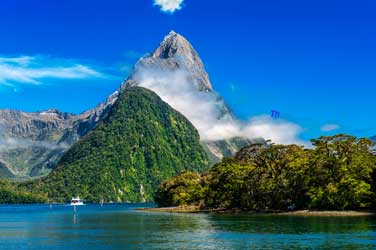
It currently covers 3,555 square-kilometres, making it the third largest national park in New Zealand, at the southern end of the Southern Alps.
The park is directly west of Lake Wanaka and is a popular destination for tramping, walking, and mountaineering.
The park is home to a number of mountains that draw mountaineers from all over the world, including, Mount Aspiring/Tititea (3,033m), which is the peak from which the mountain derives its name, Mount Pollux (2,542m), and Mount Brewster (2,519m).
The park is also stocked full with a variety of other alpine, natural attractions, such as glaciers, river, valleys, and alpine lakes.
What to Do – Mount Aspiring National Park
Mount Aspiring National Park is a hikers paradise, offering a variety of shorter walks that are great for a day trip out enjoying the park’s natural beauty.
These shorter walks include the Routeburn Nature Walk, Haast Pass Summit, Lake Sylvan, and the Blue Pools Walk. The Blue Pools Walk is one of the most popular short walks on the South Island.
Taking only 30 minutes, walkers can enjoy passing through beautiful silver beech/tahina forest and over a swing bridge.
The track ends at a viewing platform that allows walkers to look out over the crystal clear water at the mouth of Blue Lake.
More adventurous hikers can also enjoy an array of longer walks where they can travel though wonderful scenic valleys and traverse mountain saddles, such as on the Routeburn, the Dart/Rees River circuit, the Greenstone/Caples track, and the Wilkin Valley Tracks.
In the summer, walkers can walk from one valley all the way to another by traversing the higher elevation mountain passes.
These passes offer stunning views of the surrounding area. The area that is now Mount Aspiring National Park has been hiked for hundreds of years.
Long before European settlement, the Maori used to trek through the very same land in order to reach the pounamu fields of the west coast.
Mount Aspiring National Park – Routeburn Track
Arguably the most well known trail in the Mount Aspiring National Park is the Routeburn Track. This 32 kilomertre track will take the average walker around three days to complete.
The track is an intermediate grade and it is best traversed between late October and late April.
The track boasts soaring mountain peaks, stunning valleys, waterfalls, and lakes with striking, clear water.
The highest point on the track is 1,255m above sea level, thus allowing for wonderful views. The track also links the Mount Aspiring National Park with Fiordland National Park.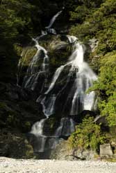
The area that the track runs through was created by successive periods of glaciation, leaving behind fjords, rocky coasts, huge cliffs, glacial lakes, and beautiful waterfalls.
The track is also filled with an abundance of birdlife, including native tomits, robins, fantails, wood pigeons, bellbirds, and cheeky Kea, the world’s only alpine parrot. The track is not a loop track and as such, it can be walked in either direction. Here is a quick guide for hiking the track.
1) Day 1: Routeburn Shelter to Routeburn Falls Hut, 8.8 kilometres. After leaving the car park, you will cross a swing bridge before passing through stunning beech forest and walking along the Routeburn Gorge.
A second swing bridge will take visitors to open, grassy flats, prior to climbing up through more beech forest. Walkers will cross over two more swing bridges prior to ending at the Routeburn Falls Hut.
2) Day 2: Routeburn Falls Hut to Lake McKenzie Hut, 11.3 kilometres. Day 2 starts with a steady climb to the outlet of the river at Lake Harris.
While it is a long climb to the top of Harris Saddle, the highest point on the track, it is worth every step as the views are absolutely stunning.
The top of the saddle is surrounded by the Darren Range, Mount Madeline, and Mount Tutoko, among others. The track then heads down towards the Hollyford Valley, eventually ending at the Lake McKenzie Hut.
3) Day 3: Lake McKenzie Hut to The Divide, 12 kilometres. After leaving the Lake McKenzie hut, walkers will wind through a grassy region dotted with a few trees prior to arriving at the 174m high Earland Falls.
The track then begins a slow descent down to the Lake Howden Hut, which is a great lunch spot. From there, the track climbs up to the Key Summit Track turnoff.
From here, walkers can enjoy wonderful, panoramic views of the surrounding area. Walkers then pass through one more beech forest prior to reaching the divide on Milford Road.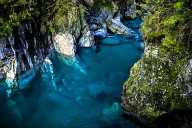
Walkers can stay at any of the four public huts along the way. All four are run by the Department of Conservation.
There are also an additional two huts that are run by Ultimate Hikes, a private organization.
The DOC huts are equipped with mattresses, flushing toilets, running water, and cooking facilities.
During the offseason, cooking facilities and running water is not present, so if you are walking during this time, plan accordingly.
As the trial is not a loop, walkers must arrange transport at both the beginning and the end of the trail. Shuttles and buses are easy to book in advance.
One end begins near Queenstown, which is filled with accommodation and transportation options.
The park is also a fantastic place for mountaineering and heli-skiing. Mountaineers can choose from a variety of different ascents, including Mt. Awful and Mt. Aspiring.
There are a variety of guiding companies that provide instruction for those who hope to do some mountaineering during their stay in the park.
As for heli-skiing, the Northern Buchanans and Albertburn are both ideal spots for those looking to hit the slopes.
Visitors to the park should be aware of the following things:
1) Due to the high elevation of the park, it is best to undertake the majority of the walks between November and March.
2) The Kea can, “take an unhealthy interest in visitors’ packs and tents.
3) Visitors should always check with the DOC prior to embarking on a longer walk.
4) The change from summer weather to winter weather can occur very quickly in this park.
5) Only the Matukituki Valley can be safely walked year round.
Mount Aspiring National Park – Accommodation
The park itself is home to a variety of huts that can be booked prior to your visit to the park.
Additionally, the park is relatively close to Wanaka, Queenstown, Glenorchy, and Te Anau, all of which have a variety of accommodation options that are sure to please any taste and budget.
Travelling from Abroad?
The park(Mount Aspiring) is in close proximity to Queenstown, which is accessible by road, bus, and air.
The town receives flights from a variety of domestic locations as well as a number of locations in Australia, including Brisbane, Gold Coast, Melbourne, and Sydney. From there, the park is accessible by road.