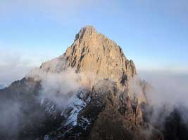
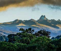
Mount Kenya is Africa’s second highest mountain at 5,199m (17,058 feet) and the highest of all Kenya Mountains.
Mount Kenya is roughly circular, about 60km across at the 200mm contour, where the steep font hills rise out of the gentler slopes of the centered highlands.
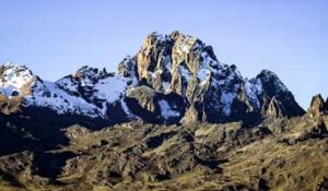
At the centre of the massif, the main peaks rise sharply from around 4,500m to the main summit of Batian 5,199m, Nelion 5,188m and point Lenana 4,985m.
Other major summits on the mountain include Point Piggott 4,957m, Point Dutton 4,885 and Point John 4,883m.
Of the three main peaks (Batian, Lenana and Nelion), only point Lenana can be reached by trekkers and the other two being only for technical climbers.
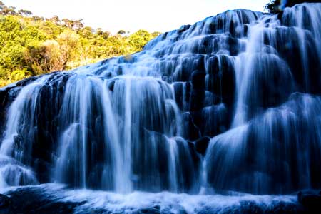
Glacier on Mount Kenya
Unfortunately, the truth about Glaciers on mount Kenya, only in some cases and at higher points.
Every year there is less and less new ice accumulating in winter than melting over summer season, even on the most popular Lewis Glacier in winter, so there is no clear evidence of new ice formation.
It is predicted to be less than 30 years before there will no longer be beautiful Glacier on Mount Kenya means the second highest point of Africa.
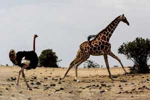
Standing a few several meters adrift in the shadows of Mount Kilimanjaro which lies some 320km away in the south and is visible on a clear day is Mount Kenya, Kenya’s tallest mountain and the second tallest mountain in Africa rising to an altitude of 5199 meters above sea level, it is known by the local kikuyu community as Kirinjuga, translating ‘there is an ostrich’ due to its black and white appearance.
The mountain has a pristine wilderness having lakes, tarns, glaciers, dense forests, mineral springs and a selection of rare and endangered species of animals, high altitude adapted plains game and unique montane and alpine vegetation.
The rock on Mount Kenya can be of variable quality but is at its best high on the mountain where the syenite rock is similar to granite – rough, hard and well-endowed with features.
It has a stratovolcanic landscape of rugged glacial-clad summits, Afro- alpine moorlands and diverse forests that illustrate outstanding ecological processes that undertook its formation.
The mountain was created approximately 3 million years after the opening of the East African rift and it last erupted between 2.8 to 3.2 million years ago.
The mountain was inscribed by UNESCO as a World Heritage Site due to having the most impressive landscapes in the whole of East Africa.
Since 1978, the area is also an International Biosphere Reserve. The elevation range of the mountain is approximately 2200 meters to 5200 meters and includes several distinct vegetative zones having Mixed broad-leaf forest, Gallery Forest, Bamboo, Giant Heath and Hagenia, moorland tussock grasses, Giant Senseco and Lobelia-and, at the uppermost elevation, rock and ice.
On the Mt. travelers can enjoy mountain climbing, camping and caving with the mountain’s rugged glacier-clad peaks providing the perfect background.
Far from being a just single peak Mount Kenya is in fact a ridge consisting of a multitude of imposing spires, cliffs, complex ridges and peaks.
These are the weathered remnants of a large extinct volcano that was active several million years ago.
Mount Kenya straddles the equator but is sufficiently high to receive significant snowfall and to be circled with several glaciers.

The mountain offers a wealth of excellent and diverse climbing possibilities on rock, snow and ice comparable to none in the region.
Apart from the superb climbing prospect on Mount Kenya, its tarns and alpine meadows, exotic, equatorial, high-altitude vegetation, sunbirds, hyrax and soaring eagles make the walk around the peaks one of the most beautiful expeditions in the East African Mountains.
Within the foot hills of Mt. Kenya is an area of 2,800 kilometer square which was designated as a National Park and a Reserve which houses more than 800 recorded plant species with 81 species being endemic to Mount Kenya.
Also in the park there is a wide variety of wildlife such as the African elephant, bushbuck, waterbuck, hyena, colobus monkey, white- throated guenon and common at higher altitudes, the ubiquitous Monte Kenya rock hyrax, also it is home to the famous giant Groundsel and many other Lobelias.
Animals rarely seen include leopard, bongo, giant forest hog and rhino. Also it should be noted that Mount Kenya is the source of the name of the Republic of Kenya.
The mountain provides every traveler out of the 16,000 travelers per year with breathe-taking beauty and an adventure not to be forgotten many years to come and fond memories to take home.

Mount Kenya – HOW TO GET THERE
Nestled some 200 kilometers North-Northeast of Nairobi, in the central province of Kenya and about 16.5 kilometers from the equator.
The traveler can be able to reach the Mountain by either road or air, but for the latter there are no airstrips within the park’s premises although the closest accessible airstrip is in Nanyuki Town.
By road the traveler can decide to use either of the following routes; Nanyuki-Isiolo Road or the Nyeri-Nakuru Road, the mountain is also reachable through Chogoria on the Embu-Meru Road.
A variety of road transport options such as; Buses, minibuses, taxi or a hired car will get the traveler there.
The last stretch of the journey from Nakuru town to the various trailheads of the mountain will be on dirt roads and these can be in poor conditions especially during the wet weather and a four-wheel drive is a necessity not a luxury to get you there, or an approach on foot should do the trick.
BEST TIME TO CLIMB – Mount Kenya
Mount Kenya is climbable throughout the year but due to the mountain lying on the equator it is affected by the passing of the Intertropical Convergence Zone which brings with it many millimeters of rainfall.
The peak rainfall occurs between late March and the middle of May, and slightly less between late October and mid-December.
The zones of the mountain that receives maximum rainfall is the forest belt and on the south-east side of the mountain where it reaches 2500mm of rainfall per year at 3000 meters above sea level.
Rain and, higher up, snow can however be encountered at any time of year even during the driest periods that is January and February.
Normally the drier seasons are associated with clear, dry weather which can last for many days on end.
The best weather is generally in the mornings, and convectional rainfall, if any, tends to come in the mid-afternoon.
Precipitation tends to decreases with altitude and is about 700 millimeters per year at 4500m.
Temperatures range considerably with height and with time of day. At 3000m.
On the plains surrounding Mount Kenya the average day temperature is about 25°C. Frosts might be encountered during night time while day temperatures range from 5 degrees centigrade to 15 degrees centigrade.
Night time temperatures on the summit are well below the freezing point. The south-facing side of Mount Kenya receives more sunshine between December and March period.
During this time rock climbs are “in-condition” and snow and ice climbs gradually deteriorate. In the June to October period the north-facing rock climbs and south-facing ice climbs are best.
As quoted by the Mountain Club of Kenya; “Travelers attempting either the Diamond Couloir or the Ice Window between Christmas and March is stretching the limits of calculated risk.”
Popular Peaks on Mount Kenya
The peaks on Mount Kenya are almost all from volcanic origins where the majority of the peaks are located near the center of the mountain.
This peaks on Mount Kenya got their names from three different sources; firstly, several Maasai chieftains have been honored on the mountain with peaks such as Batian, Nelion and Lenana.
Those names of peaks commemorate Mbatian, a Maasai Laibon (Medicine Man), Nelieng his brother, and Lenana and Sendeyo, who were his sons.
Terere is named after another Maasai headman. The second type of names that were given to peaks are after European climbers and explorers. Some examples of this are Shipton, Sommerfelt, Tilman, Dutton and Arthur.
The remaining names are after well-known Kenyan personalities, with the exception of John and Peter, which were named by the missionary called Arthur after two disciples written in the Bible.
There is a group of four peaks to the east of the main peaks named after European settlers; Corydon, Grigg, Delamere and McMillan.
The main summits are the twins Batian (5,199 meters) and Nelion (5,188 meters), and these can only be reached by means of technical climbing via a variety of rock or ice routes.
The third highest peak, Point Lenana (4,985 meters), is a popular destination for trekking parties. Batian and Nelion are within 250 meters of each other and are separated from each other by the Gate of the Mists gap (5,144 meters).
Corydon Peak (4,960 m) is the next highest, but unlike the previous peaks it does not form a part of the central plug. Other peaks around the central plug include Pt Piggot (4,957 m), Pt Dutton (4,885 m), Pt John (4,883 m), Pt John Minor (4,875 m), Krapf Rognon (4,800 m), Pt Peter (4,757 m), Pt Slade (4,750 m) and Midget Peak (4,700 m). All of these have a steep pyramidal form and offer good rock climbing routes.
Craggy outlying peaks include Terere (4,714 m) and Sendeyo (4,704 m) which form a pair of mirror image peaks to the north of the main plug.
Together they form a large parasitic plug. Other notable peaks include The Hat (4,639 m), Delamere Peak, Macmillan Peak and Rotundu.
These peaks have an Alpine appearance due to their craggy nature. Typically of Alpine terrain, the highest peaks and gendarmes occur at the intersection of ridges.
The central peaks only have a few mosses, lichens and small alpine plants growing in rock crevices. Further away from the central peaks, the volcanic plugs are covered in volcanic ash and soils.
The vegetation growing on these peaks is typical for their vegetation band. The traveler should take nothing but memories and leaving nothing but footprints on the mountain.
Mount Kenya – Trekking Routes
Travelers planning to venture to the various peaks on Mt. Kenya can be able to trek to the peaks or climb to the peaks depending on the traveler’s preference.
There are eight trekking routes in total up to the main peaks but not all routes are used while trekking.
Starting clockwise from the north these are; the Meru route, Chogoria, Kamweti, Naro Moru, Burguret, Sirimon and Timau Routes.
Of these routes Chogoria, Naro Moru and Sirimon are the most frequently used and hence have staffed gates, this routes will be discussed in detail below.
The other routes require special permission from the Kenya Wildlife Service to use them.
The Chogoria Route
The Chogoria route leads from Chogoria town up to the peaks circuit path and is said to be the most scenic and interesting of all the routes on the mountain.
The route begins from chogoria town; about 96 km from Embu and 64 km from Meru town and it is tackled from the West side of the mountain.
It heads through the forest to the south-east of the mountain to the moorland, with views over areas such as Ithanguni and the Giant’s Billiards table before following the Gorges Valley and onto the beautiful Lake Michaelson, the route passes past the Temple and up to Simba Col below Point Lenana.
Ernest Carr, who made a vehicle track to the moorland, opened it in the1920s.
It is however, a much longer route, compared to the others.
The Ithanguni Billiard and the Giant’s Billiard Tables offer some of the best hillwalking in Kenya ensured to thrill the traveler.
Camping is possible at the road head and water is available from a stream that passes by. Mintos Hut (4,300m) is an excellently sited hut on the plateau overlooking Lake Michaelson 300m below.
Spectacular views can be sighted at the Nithi George, by walking ten minutes south-east of the Mintos hut to the edge of the “Temple.” From Hall Tarn the trail continues to the Austria Hut (4,790m) via square Tarn and the Tooth Col, then round the head of the Hobley Valley.
Alternatively Shipton’s Camp (4,200m) may be reached (3 hours), via Simba Col. Descend down is made towards lower Simba Tarn and turn left to Shipton’s Camp.
The chogoria route will take the traveler a distance of 50 kilometers up to Point Lenana at 4985 meters above sea level during a period of 5 days, 4 days ascending with the remaining one day is used for descending.
Timau Route
The Timau Route has a fantastic charm as it brings a feeling of solitude and peace into a great mountain hike.
The route brings to life some of the most beautiful and scenic sites on the mountain, it is also a traveler’s best chance to see wildlife and birdlife at higher altitudes, with an abundance of Zebra, Eland, Duiker, Buffalo, and if you’re really lucky Cats.
As one famous saying goes by “The higher you go the cooler it becomes” hence at the foot of the mountain the altitude is 2700m whilst at the summit the altitude is 4985 m above sea level.
This hike starts off at the start of the Moorland Zone and takes you up through patches of bamboo and heather.
An early start is required to prepare for the two and a half hour walk to the summit, where you will watch the best sunrise you will ever see and maybe even get a glimpse of Mt Kilimanjaro.
breathtaking views of the Massifs of Batian and Nelion and of the valleys below as they are slowly illuminated by the sun’s rays can be seen.
Enjoy a hot cup of tea or hot chocolate and reflect on the achievement with this magnificent view.
The distance to the summit is 36 km and the summit point with this route is lenana point. All in all it takes up to 4 days up and one day to descend down on the southern side of the mountain.
Camping equipments are set up by a team of expertly trained local porters and guides, who ensure that a traveler will always feel comfortable throughout the expedition.
The Naro Moru Route
The Naro Moru route is the most popular route onto the mountain and fastest,hence it is taken by many of the trekkers who wish to reach Point Lenana, this route approaches the mountain from the West.
The route is not particularly scenic and the rapid ascent profile makes the route unsuitable for climbers wishing to acclimatize more sensibly.
It can be ascended in only 3 days and has bunkhouses at each camp.
The route starts at Naro Moru town to the west of the mountain and climbs towards Mackinder’s Camp at 4,200 meters above sea level before joining the Peak Circuit Path.
The terrain is usually good, although one section which the traveler has to overcome is the legendary Vertical Bog, a steep quagmire of wet moorland that is tremendously demanding and unpleasant after the rains.
The final climb up to Point Lenana tackles a long, loose and uncompromising scree slope up the side of the Teleki Valley. Descending down the Naro Moru route is quite pleasant.
The Sirimon Route
The least used of the four main trekking routes is the Sirimon route which approaches Mount Kenya from the north-west.
This route provides the easiest and most scenic access to the Northern side of the central peaks, which include Batian, Nelion and Lenana.
The track is 15 km from Nanyuki town heading towards Meru town. The gate to the starting point of the trek is 10 km (6 miles) further along the track, which can be walked or driven by two-wheel drives.
The route features the most gradual ascent profile and the best acclimatization option for travelers.
The path splits on the moorlands with the more frequently used fork following the Mackinder Valley and the quieter route traversing into the Liki North Valley rising to a height of 4000 meters.
The path passes through magnificent yellowwood forests in the lower reaches and features abundant wildlife and beautiful alpine scenery high up the mountain.
The paths rejoin at Shipton’s Cave at an altitude of 4,200 meters just below Shipton’s Camp on the Peak Circuit Path.
There are two permanent camps where a traveler can camp while hiking with this route and those are the Old Moses camp at 3300 m and Shipton’s camp 4200 m overlooking the main peaks of the mountain.
From the Mackinder valley, where the Shipton camp stands, you have the panoramic view of all the main peaks including Terere and Sendeyo two ancient parasitic vents of the main peaks.
A traveler can also have the unique chance to cross the Equator both at Nanyuki and on your way to Old Moses Camp while ascending with this route.
Water is also plentiful throughout in streams which can be used for drinking and other uses although astonishingly, being on the northwestern side of Mt. Kenya, the route generally escapes some rainfall, making it drier than other routes most time of the year.
The Summit Route
The Summit Circuit Path is a path around the main peaks, with a distance of approximately 10 kilometers and height gain and loss of over 2,000 meters, the traveler will pass along the way the following features such as; the American Camp in the Teleki Valley, Two Tarns, Hausberg Col, Kami Hut / Shipton’s Camp, Simba Col, Tooth Col, Austrian Hut and then back down to the Teleki Valley.
It can be walked in one day, but more commonly takes two or three days. It can also be used to join different ascent and descent routes.
Burguret route
The route starts from Mountain Rock Hotel, and goes through the forest past Gathiuru Forest Station to an indistinct road head at the end of the plantation area – 2,500m above sea level.
The trail continues from here to elephant camp 2,600m. The trail cuts through tropical rainforest till it gets to the more open Hagenia –Hypericum Zone 2860m and eventually to the Heath Zone from where one can now clearly see the peaks.
Further on, after the castle, there is a good campsite ‘kambi ya farasi’ a Swahili word that translates to horse camp.
It is a public camp and a traveler can always enjoy the adventure of setting up the tents for those that enjoy doing so but help is always available if required.
From ‘kambi ya farasi’, the trail swings left and climbs steeply out of the valley. The ridge bears right again, and a walk over rocky ground brings a traveler round the hill.
The trail then turns to the left via the Hausberg Col and Oblong Tarn to Mackinder’s valley and descends down to Shipton’s Camp (4,200m).
The Climbing Routes
Most of the peaks on Mount Kenya have been summited but out of the 16,000 visitors coming to climb Mt. Kenya only 250 travelers have been able to summit Nelion and Batian, the two highest peaks on the mountain. The highest peak that can be ascended without climbing is Point Lenana at an altitude 4,985 meters.
The majority of the routes on Mount Kenya involve rock climbing as the easiest course.
Batian Point when ascended directly is climbed via the North Face Standard route, and it takes up to two days to be climbed.
The normal route however, is the most climbed route up Nelion, and hence across to Batian. It is possible to traverse between the two peaks, via the Gates of Mist, but this often involves spending the night in the Howell hut on top of Nelion.
There is a bolted abseil descent route off Nelion.
The Austrian Hut at 4800 meters is the base camp for the parties doing the Nelion Normal Route and the hut is reached easily from any of the three trekking routes.
Climbers doing the North Face Normal Route on Batian will use Shipton’s Camp or Kami Hut as a base.
Mount Kenya is also home to good several ice routes, the two most famous being the Diamond Couloir and the Ice Window route.
Snow and ice levels on the mountain have been disappearing at an alarming rate in recent years, making these climbs increasingly difficult and dangerous. The Diamond Couloir is a steep ice couloir fed by the fusion of the upper Diamond Glacier.
The Diamond Couloir was once climbable in summer or winter but now is virtually unclimbable in summer conditions due to the melting of the ice and snow and is even not often deemed climbable condition even in winter.
Last climbing reports describe the route being very difficult, especially in the lower section.
The route has changed into a modern ice climb with a very difficult 60m first pitch, starting with 8 meters of overhanging dry tooling, followed by 50m of ice.
The satellite peaks around the mountain also provide good climbs.
Mount Kenya climbing seasons are a result of the mountain’s location from the equator. During the northern summer the rock routes on the north side of the peak are in good summer condition, meanwhile the ice routes on the south side of the peak are in prime shape.
The situation is reversed during the southern summer. The two seasons are separated by several months of rainy season before and after, during which climbing conditions are generally unfavourable.
ACCOMMODATION – Mount Kenya
Accommodation on Mount Kenya ranges from very basic to luxurious accommodation facilities. The more luxurious lodges are found on the lower slopes, in and around the forest.
These lodges have hotel-style accommodation, often with log fires and hot running water. Many offer guided walks and other activities such as fishing and bird watching.
The huts higher on the mountain are more basic. Most have several bunk rooms with beds, and also offer somewhere to rest, cook and eat.
Some also have running water. A few huts are very basic bothies only offering a space to sleep that is sheltered from the weather. Beds in the huts can be reserved at the park gates.
Camping is allowed anywhere in the Park, but is most encouraged around the huts to limit environmental impact. It is possible for travelers to use the communal spaces in the huts for no extra fee since camping fees are included in the park fees on arrival.
There are a number of huts around the base of the mountain and on the various trekking routes. Additional fees are payable for staying in any of these and reservations should be made in advance.
The major huts on the mountain include: Judmaier Hut on Sirimon Route which is managed by the Mountain Rock Hotel, the Shipton’s Hut on Sirimon Route also managed by the Mountain Rock Hotel, the Met Station Hotel on the Naro Moru Route.
The Mackinder’s Hut on the Naro Moru Route both of which are managed by the Naro Moru River Lodge, Austrian Hut on Lewis Glacier which is managed by Mt. Kenya National Parks, The Top Hut on Lewis Glacier also managed by the Mountain Club of Kenya, Baillie’s Bivi on the Normal Route managed by the Mountain Club of Kenya and Howell Hut on the summit of Nelion also managed by the Mountain Club of Kenya.

OTHER ATTRACTIONS AND THINGS TO DO – INFORMATION
The Ol Pejeta Conservancy
Situated on the foothills of Mt. Kenya and the Aberdares, the ol pejeta conservancy started off as a ranch because Laikipia Plateau was used as an extensive cattle ranching area.
Lacking the rainfall required to successfully cultivate crops, cattle ranching was seen as the next best way to utilize the land. In those days, wildlife was perceived as having little or no value to landowners of the ranch.
Herds of migrating elephant regularly destroyed the fenced enclosures making intensive cattle farming impracticable.
Cattle still plays a role in Ol Pejeta today but as a managed livestock within the conservancy and is used to maximize the biodiversity of the land making Ol Pejeta an integrated wildlife and livestock area.
Since its inception in 1988 Ol Pejeta has had a colorful list of previous owners including Lord Delamere, an early and influential settler from Britain, shipping tycoon Aristotle Onassis’ father Roussel and the famous arms dealer Adnan Khashoggi.
In 2004, the ranch and surrounding land was purchased by the UK-based conservation organization Fauna and Flora International with the financial backing of the Arcus Foundation, a private international philanthropic organization founded by Jon Stryker.
The Ol Pejeta Conservancy is a 90,000-acre (360 km2) not-for-profit wildlife conservancy in Central Kenya’s Laikipia County.
It is situated on the equator west of Nanyuki. The Ol Pejeta Conservancy works to conserve wildlife, provide a sanctuary for great apes and to generate income through wildlife tourism and complementary enterprises for re-investment in conservation and community development.
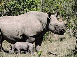
Ol Pejeta has over 10,000 large mammals and it is the only park where the big 5 and chimpanzees can be seen. It is also where the fastest growing population of rhino in Africa can be found.
There are southern white rhino, about 80 endangered black rhino and in a special sanctuary there are three of the world’s last four remaining northern white rhino who were moved here from Dvůr Králové Zoo in the Czech Republic.
The males are named Sudan and Suni while the females Fatu and Najin. The rhinos enjoy 24-hour armed security and a 700-acre enclosure.
Suni was seen mating with Najin in 2012, but tests have confirmed she is not pregnant. Such is the plight of this species that Ol Pejeta is trying to cross-breed the closely related southern white rhinos with the northern whites, to preserve northern white rhino genetics in hybrid offspring. On 17 October 2014, Suni died from unknown causes but not because of poaching.
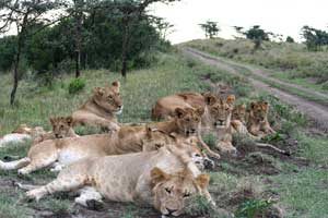
All members of the “Big five game” (lion, Cape buffalo, African elephant, leopard and rhinoceros) can be found on the Ol Pejeta Conservancy.
Both black and white rhino thrive here. In 2013, Ol Pejeta recorded the birth of its 100th black rhino. It is one of only eight sanctuaries in Africa with this distinction.
The Endangered Species Boma is a must-see for any traveler to Ol Pejeta. Here travelers can meet up and learn about the Northern White Rhinos which are critically endangered with only three left in the world.
All of them are here and travelers can have the unique experience of seeing these majestic creatures up close. The boma also has six southern white rhinos, two black rhinos and numerous Gravy’s zebras and Jackson’s hartebeest.
In the conservancy is Baraka one of the first rhinos born on the Ol Pejeta Conservancy.
After losing an eye to an infection following a fight Baraka unfortunately developed a cataract in the other eye and subsequently became completely blind.
With a low chance of survival on his own, Baraka was moved from the wild to a 100 acre enclosure in order to ensure his safety.
Baraka is now an ambassador for his species and a popular attraction at Ol Pejeta.
There is a feeding platform from which travelers can get up close to view and feed him, an experience not to be missed.
Baraka receives visitors daily from 9.30am to 6.00pm, with feeding times three times per day.
Safari by vehicle is not the only option at Ol Pejeta for a traveler. Game walks, horse rides and even camel rides are available, as are night game drives.
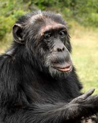
Sweetwater Chimpanzee Sanctuary
The Sweetwater Chimpanzee Sanctuary is incorporated within the Ol Pejeta Conservancy and is the only place in Kenya where a traveler can see this highly endangered and remarkably intelligent species.
The Sanctuary was officially opened in 1993 in a negotiated agreement between the Ol Pejeta Conservancy, the Kenya Wildlife Service (KWS) and the Jane Goodall Institute.
The facility was initially established to receive and provide lifelong refuge to orphaned and abused chimpanzees from west and central Africa.
An initial group of three chimpanzee orphans were brought to the sanctuary from a facility in Bujumbura, Burundi, that needed to be evacuated due to the civil war.
This was followed in 1995 by another group of 9 adult chimpanzees, and another 10 in 1996.
Over the last decade Sweetwater Chimpanzee Sanctuary has been obliged to keep accepting chimpanzees rescued from distressing situations bringing up the total number of chimpanzees in the sanctuary to 43.
Access to see the chimpanzees is by taking a water vessel and sailing across the clear waters.
At the Sweetwater Sanctuary, chimpanzees are nursed back to health and enjoy the rest of their days in the safety of a vast natural enclosure.
The chimpanzees live in two large groups separated by the Ewaso Nyiro River. It is the only place in Kenya where non-indigenous chimpanzees can be seen.
Main Peaks of Mount Kenya in M & FT
Batian (5199 m – 17,058 ft)
Nelion (5188 m – 17,022 ft)
Point Lenana (4985 m – 16,355 ft)
Coryndon Peak (4960 m – 16,273 ft)
Point Pigott (4957 m – 16,266 ft)
Point Thompson (4955 m – 15,466 ft)
Point Dutton (4885 m – 16,027 ft)
Point John (4883 m – 16,016 ft)
Point Melhuish (4880 m – 16,010 ft)
Point John Minor (4875 m – 15,990 ft)
Krapf Rognon (4800 m – 15,740 ft)[17]
Point Peter (4757 m – 15,607 ft)
Point Slade (4750 m – 15,580 ft)
Terere (4714 m – 15,462 ft)
Sendeyo (4704 m – 15,433 ft)
Midget Peak (4700 m – 15,420 ft)
The Hat (4639 m – 15,220 ft)
Mount Kenya Climbing Charges
Travellers think that they can do anything Africa No, you can’t climb the mountain free and have to pay national park taxes. Travellers will have to pay the park entrance fees which are very reasonable for Mount Kenya.
The park fees are: US $70 for adult non-residents for the first three days + $20.00 per day for every additional day.